

The scan map
See where your items are scanned, unit by unit with its B2B order, distributor and zone, which units never were, and the gray-market alerts.
On this page
This screen shows where your products are scanned. Scans are grouped by place: a scan whose device sent its position is a dot, a scan known by its network only is an approximate zone. You open it to read the real geography of your scans, and to spot geographically impossible sequences between two scans of the same identifier.
#What the screen shows
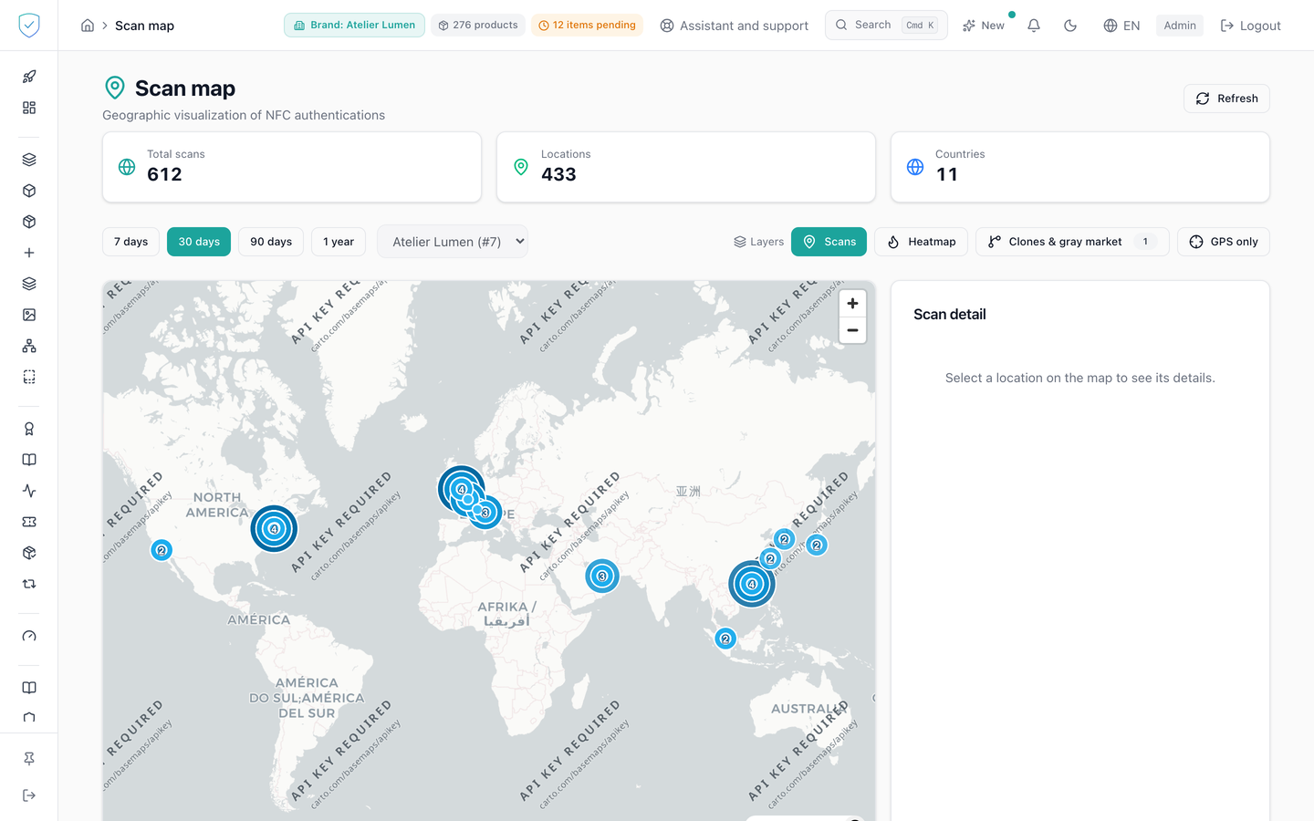
The map takes two thirds of the width, a panel the remaining third. In the panel, four boxes. The first one says what it counts and over which period, for instance "Item scans · last 30 days": it is the same number, computed the same way, as the dashboard's "Item scans" tile over the same period (see the dashboard). The second one, "Precise position (GPS)", adds up the scans whose device sent its position. The third one, "Approximate zone (network)", adds up the scans placed from their network only: they are drawn, but never counted as located. The fourth one gives the possible copies still open, with no period. Four period buttons, "7 days", "30 days", "90 days" and "1 year".
The map looks at the brand chosen in the top bar, like the rest of the console, and the subtitle names it. A superadmin can switch to "All brands" with the cross of the pill that names the brand; that choice ends as soon as the top bar's brand changes.
Five toggles drive the map: "Scans", "Clones", "Gray market", "Units" and "GPS only". When the screen opens, "Scans" and "Units" are on. The dots are of one colour, and their size tells the number of scans. An approximate zone is a see-through disc with an outline, about a town wide, never a solid dot: it says where the network comes out, not where the person was. The map's colours follow the console's light or dark theme, and switching theme repaints the map without reloading it. Roads and buildings only appear when zooming in on a city.
Below the map, a legend: "GPS position (≈ 1 km)", "approximate zone (network)", "possible copy" and "gray market (outside the authorized countries)". A sentence gives the number of scans that came from a server network (hosting provider, data centre, most VPNs): they are counted, never placed. Another one gives the number of scans that have neither a device position nor a town known from their network.
The "Scan detail" panel gives the place, where it comes from with an explanation, the number of scans at that spot, its share of all scans, and the coordinates to two decimals: the device's position, or the centre of the zone. A GPS place is said to be "near" the town closest to its point. The "Top locations" table is a real table of 25 rows at most, which the map does not replace: a skip link, right before the map, leads to it directly from the keyboard.
#Each scanned unit, and its card
The "Units" layer places each unit scanned over the period where it was last scanned. Units close together gather into a bubble that carries their number; clicking the bubble zooms in until they separate. A unit scanned outside its zone takes the gray-market colour. Clicking a unit opens its card:
- the product, its reference (the model's SKU) and its serial number;
- the lot;
- the B2B order, with a link to the order's page, and the distributor;
- the distributor's territory, or else the authorized countries of the model or of the brand;
- the country of the scan, and whether it is inside or outside the zone;
- where the place comes from, in plain words: "precise GPS position (about 1 km)", "town known by the network (approximate)" or "Apple Private Relay region (approximate)";
- the date of the last scan, and the status of the unit's gray-market alert if there is one.
Clicking a disc of the "Gray market" layer opens the same card for the alerts of that place, latest first, five at most: product, reference, lot, order, distributor, territory compared, country, where the place comes from, date and alert status. For a declared sale, the place is "address of the shop that declared the sale".
The card also shows in the right-hand panel. Under the map, the "Latest scanned units" table lists the 50 most recent: choosing a row, from the keyboard or the mouse, opens the same card and centres the map.
A unit is counted on its last successful scan of the period. A scan from a server network is counted and never placed, as on the "Scans" layer. The map receives 2000 units at most (5000 on request); beyond that, the count reads "At least … units" and a sentence asks you to narrow the period or add a filter. The zone filter applies before that limit: an older unit outside its zone is never hidden by more recent scans. Coordinates are given to two decimals, about 1 km.
#The filters
Four lists, above the map: "Distributor", "Order", "Lot" and "Zone" (inside the zone, outside the zone, country unknown). They narrow the units, the coverage and the "Gray market" layer. The zone applies to the units only: a gray-market alert is always outside its zone. The order list only shows the orders of the chosen distributor. "Clear filters" sets them all back to "All".
The page of an order and the page of a lot have a "See on the scan map" link that opens the map already filtered on them.
#The coverage
The "Coverage" panel tells, for each distributor, each order and each lot, how many units were scanned at least once by a consumer and how many never were. For an order or a distributor, only scans made after the unit was picked into the order count: a warehouse scan before shipping says nothing about the market. For a lot, every scan counts, and only minted units in service are counted. The coverage does not depend on the period. The 200 most recent orders and the 200 most recent lots are listed. Clicking a name filters the map on it.
The same rule gives the "Never scanned" figure of the order's page (see B2B shipping) and the "Scan coverage of this lot" card of the lot page: the three screens count alike.
#What you can do here
Change the period, which is 30 days when the screen opens. Turn each of the four layers on or off. Filter by distributor, order, lot or zone. Click a unit or an alert to open its card. Restrict the table to the positions sent by a device alone, with "GPS only". Click a place in the table to center the map on it and open its detail. "Refresh" restarts the read.
The NFC and QR split does not exist here: the channel is frozen on every scan, with no selector.
#What conditions access
The "Scan map" entry lives in the "Analysis & Audit" section, and the content waits until the account is recognized as an administrator.
The units, the coverage and the cards only read your brands: another account's brand asked for as a parameter is refused, and a distributor, order or lot of another brand answers as if it did not exist. They only read the pieces that carry identity: those of a brand on the Compliance + Identity offer, and those minted under that offer before the brand changed it.
On the Compliance offer, a scan is a scan of a model or lot code. It is counted per month, with no position at all: the map could not place any of them. The screen is therefore reserved to the Compliance + Identity offer: the menu entry is locked and marked "Identity", like the claim rules, and the address typed by hand leads to the same lock. The number of code scans of the current month is on the dashboard. Scope is applied server-side, every scan being tied to its product and therefore to its brand. A place only becomes clickable, and is only drawn, if it has coordinates: the device's position, or the centre of the network's town. A server network never has any.
⚠️ The base map tiles come from OpenFreeMap, a third-party service with no service commitment, which sees the signed-in person's IP address and the area looked at. That is accepted on this internal console screen; no interactive map will be shown anywhere else before those tiles are served by SealTrust.
Without a GPS position, the city and country come from the IP address, looked up in the DB-IP Lite database. With a GPS position, the name comes from the GeoNames table of towns. Their CC BY 4.0 licences ask for a link to their publisher: it is in the map credits, behind the "i" button, and at the bottom of every console page, "IP Geolocation by DB-IP · Places by GeoNames".
#What the screen refuses
The provenance label follows the recorded value: "GPS", "approximate (network)", "approximate (Private Relay)" or "server network". A place is of one kind only, never a mix: the scans of a network never merge into a GPS dot.
The name of a GPS place comes from its point, through a bundled table of towns (GeoNames), never from the IP address: before this change, a dot in Lyon could carry the name of the town where the mobile network came out. A scan with no position is placed at the centre of the town the local GeoIP database gives, which states no accuracy radius: hence the zone. A scan made through Apple's iCloud Private Relay is placed in the region Apple publishes for it. A scan from a hosting provider is never placed. None of these decisions calls an outside service, and only the provenance is stored, never the address.
On the public product page and on the verification page, the person scanning can choose to share a more precise location, rounded to about 1 km on their device. Nothing is asked of their browser before their click, and declining changes nothing in the result. Their scan then moves from the zone to a dot.
Only the sdm_verify_url and qr_scan steps feed the map, NFC session
telemetry being left out, as are the link-preview robots. The pair of
coordinates close to zero, a geocoding artefact, is brought back to an absence
of coordinates. Scans are grouped in a grid of cells of about one kilometre,
and the read stops at 25 pages of 200 places, that is 5000 aggregated
locations.
The clone layer only draws segments of the geo_impossible type and ignores
two scans with identical coordinates. It reads only the copies of the brand on
screen, the one in the top bar. With no brand picked it asks for nothing and
draws nothing; "All brands" stays an explicit choice of the superadmin.
When it cannot be read, the map stays on screen and its toggle is disabled, with the "Clone overlay unavailable" tooltip. That is what an account with no accessible brand, or no brand picked, gets.
The "Gray market" layer places the gray-market alerts of the period and of the brand on screen: one disc per place, its size the number of alerts, its pill the total number of alerts of the period. The place is that of the scan that created the alert, the device's position when it sent one, otherwise the centre of its network's town (a see-through disc), and for a declared sale the retailer's position. An alert with none of these places is counted in a sentence under the toggles, never placed. The rules that create an alert are those of the Distribution screen: a verified chip scan, a signed QR verification or a declared sale outside the zone, one alert per item and country in 24 hours. Opening a passport page from a printed code or a shared link stays a point of the "Scans" layer, never an alert. With no brand picked it asks for nothing and its toggle carries the "Gray-market layer unavailable" tooltip.
Was this page helpful?
Your answer opens a pre-filled email in your mail app, addressed to contact@sealtrust.io. You read it over before sending it.